On this page, we have compiled guidelines and frequently asked questions. You can use the search box or look for a suitable topic in the subject headings below.
- Download the Bikenavi app From AppStore or From GooglePlay
- Tea account and log in to the application
- An account is created using an email and password.
- Account verification is done using a link sent to your email.
- After verification, you can use the app
- Place an order or try the app
- Choose a suitable subscription duration 1, 6 or 12 months
- You can try the app For 7 days upon order
- Please note that there is also a web-based route planning service: app.bikenavi.fi
Login
- Download the Bikenavi app From AppStore or From GooglePlay
- Tea account and log in to the application
- An account is created using an email and password.
- Account verification is done using a link sent to your email.
- After verification, you can use the app but the functions are limited.
Order and trial
- Place an order on mobile or try the app with all features
- Choose a suitable subscription duration 1, 6 or 12 months
- You can try the app For 7 days upon order
- Log in to the application (app.bikenavi.fi) with the same credentials.
Routes and directions
My routes
Plan your route carefully in advance on a computer (app.bikenavi.fi)
The saved route will immediately appear in your personal routes, you can:
- Put the route on the map
- Export route as GPX file
- Deletes a route
Imported routes
You can upload a route in GPX file format to the app. After uploading, you can:
- Put the route on the map
- Deletes a route
Instructions
- You can find more detailed instructions for using the app here.
Profile
Below the profile you will find the following information.
User name
- My username (email address)
Order valid
- Subscription valid, you can see until when the subscription is valid (date).
Means of transport
You can change your means of transport
- For motorbikes
- For bicycles
The selected mode of transport is used to calculate the route in route planning and express routes.
Other
Feedback
- You can send feedback or report a problem using the web form.
Analytics
- You can influence the appearance of analytics
Reports
- See all the reports in the app
Language
- You can change the language of the app
Log out
- You can sign out of the app
Bike maps can be used anywhere in the world for route planning and navigation. In addition, pavement and other geographic information is available in Finland and Sweden.
Option 1: Draw freely
- Add or remove waypoints right-click. If you are using a phone or tablet, add a period long press.
- You can move all the points you have added freely on the map and also add waypoints to the route.
Functions on the map, mouse right button.
- Add a waypoint
- Delete waypoint
- Google Street View
If you are using a phone or tablet, the functions will appear long press.


1. Add the desired starting point
- Use on a computer right mouse button.
- On your phone or tablet long press.

2. Create a route by adding points
- It is worth adding route points, for example for turns. (The route calculation can be corrected if there are too few points.)

3. Add intermediate points
- Waypoints help you plan a complex route.

4. Adjust the route if you wish
- You can move all waypoints.

Option 2: Use addresses to help you
- Change the drawing mode from the selection

You can easily make a longer route by entering
- Address of the departure point
- Destination address
- Milestones
- All points can still be moved
1. Add your desired departure point and destination

2. Create a route by adding waypoints

3 You can add intermediate stages and waypoints to your route
Waypoints help you to make a complex route.
- You can adjust the route by moving waypoints and intermediate stages.

Routes and directions
My routes
Plan your route carefully in advance on a computer (app.bikenavi.fi)
The saved route will immediately appear in your personal routes, you can:
- Put the route on the map
- Export route as GPX file
- Deletes a route
Imported routes
You can upload a route in GPX file format to the app. After uploading, you can:
- Put the route on the map
- Deletes a route
Instructions
- You can find more detailed instructions for using the app here.
Profile
In the profile you will see:
Usernames
- Your username (email address)
Order valid
- You can see how long the subscription is valid (date).
Order from
- You can manage your subscription in the app store.
Means of transport
You can change your means of transport:
- For motorbikes
- For bicycles
The selected mode of transport is used to calculate the route in route planning and express routes.
Other
Subject:
- You can switch the app to either a light (default) or dark theme. The theme you choose will also affect the appearance of the maps.
- light theme -> light maps
- feel the theme -> dark maps
Feedback
- You can send feedback or report a problem using the web form.
Analytics
- You can influence the appearance of analytics
Compass
- You can calibrate your compass if your bearing or position does not work properly.
Language
- You can change the language of the app
Reports
- See all the reports in the app
Log out
- You can sign out of the app
1 Search
You can apply for by writing to in the search field:
- Name of (Vaasa or Neste Oulunbar)
- Address of (Isokatu 10, oulu)
- Category (e.g. petrol stations)
2 Speed dial
You can also use the shortcut, which allows you to quickly search for hotels and campsites, for example, on the map view. From the shortcut, you can choose
- Gas stations
- Pharmacies
- Hotels
- Repair shops
- Campsites
- Accommodation
- Attractions
- Banking services
- Grocery stores
3 Results
Search results are displayed below.

4 Search results on the map
Result(s) displayed on the map
- You can select the desired destination
- The location information is displayed:
- Name / Address
- You can make a Quick Route to a destination Route herebutton

Search
1 search
You can apply for by writing to in the search field:
- Name of (Vaasa or Neste Oulunbar)
- Address of (Isokatu 10, oulu)
- Category (e.g. petrol stations)
2 Shortcuts
You can also use the shortcut to quickly search for hotels and campsites, for example, in the map view.
Open the speed dial, you can choose:
- Gas stations
- Pharmacies
- Hotels
- Repair shops
- Campsites
- Accommodation
- Attractions
- Banking services
- Grocery stores

3 Search results on the map
Result(s) displayed on the map:
- You can select the desired destination
- The location information is displayed:
- Name / Address
- You can make a Quick Route to a destination by pressing the route symbol

Vehicle
You can choose as a vehicle
- Motorcycle
- Bicycle
Routing options
There are two basic choices in routing settings
- Fastest route
- Allow routing on paths. The route may include small paths, ensure drivability!
With advanced routing options, you can:
- Avoid motorways if you want to drive on quieter routes or enjoy the scenery without high speed limits.
- Avoids ferries, making the route entirely overland without crossing waterways.
- Avoids toll roads, routing to toll-free sections.
- Avoids unpaved roads, so the route only runs on paved sections
Hiding the route
- Option to hide/show route on map

The compass shows your direction of travel. This is enabled when the heading mode is selected.
Recording
Once you have planned your route Save to route. The route is saved My routes tab.
Export
- You can open a saved route in the Bikenavi mobile app
- You can export the route as a GPX file* to your desired navigation device or application
- Press the “Export route” button and select the desired file format
- Export route advanced functions My routes / New route
* GPX is a file format that allows you to transfer a route to another device or application.
Suspend
- This function interrupts route creation, no data is saved.
My routes
- Saved routes can be found My routes from the tab
- The newest route is at the top.
- Activities on the route behind 3 points:
- Route deletion
- Switching to editing mode
- Route export
Map bases
Bikenavi offers 6 different map base options.

Supposition
OpenStreetMap (OSM) is a global map database.
The map contains information about roads, paths, buildings and other points of interest.

Topo (requires subscription)
A topographic map contains a lot of detail, such as elevation contours, small roads, and bodies of water. It is well suited for outdoor activities and visualizing elevation differences.

Basic (requires subscription)
A base map helps you visualize the overall picture of the area clearly and in detail.

Lightweight (requires subscription)
A light map is simple. It lacks the detailed information of a traditional map. Roads and paths are clearly visible on the map.

Outdoor activities (requires reservation)
Designed for outdoor activities like hiking and cycling, the map provides detailed terrain information and highlights natural features.

Aerial view (requires subscription)
Aerial photos consisting of satellite images help in visualizing terrain, for example when choosing a campsite.
Coating information (Finland)
Pavement colors on the map. In the application, the information is displayed at zoom level 9.
Asphalt road
Soratie
Cobblestone
Other coating categories
Paved, road surface unknown
Private roads (Finland)
Coloring of private roads on the map. Whether weight and/or vehicle-specific restrictions have been imposed on the road. The information is displayed in the application at zoom level 11.
There are no restrictions on the road.
There are restrictions on the road.
No information about restrictions
Road works (Finland)
You can see the roads in Finland on the map.
Lipas information (Finland)
You will see the following information on the map (location information to be opened later)
- Lavas, kodas, combs
- Screens
- Cooking places
- Mountain biking trails
- Cycling routes
Map bases
Bikenavi offers 6 different map base options.
Supposition
OpenStreetMap (OSM) is a global map database.
The map contains information about roads, paths, buildings and other points of interest.
Topo (requires subscription)
A topographic map contains a lot of detail, such as elevation contours, small roads, and bodies of water. It is well suited for outdoor activities and visualizing elevation differences.
Basic (requires subscription)
A base map helps you visualize the overall picture of the area clearly and in detail.
Lightweight (requires subscription)
A light map is simple. It lacks the detailed information of a traditional map. Roads and paths are clearly visible on the map.
Outdoor activities (requires reservation)
Designed for outdoor activities like hiking and cycling, the map provides detailed terrain information and highlights natural features.
Aerial view (requires subscription)
Aerial photos consisting of satellite images help in visualizing terrain, for example when choosing a campsite.
Coating information (Finland)
Pavement colors on the map. In the application, the information is displayed at zoom level 9.
Asphalt road
Soratie
Cobblestone
Other coating categories
Paved, road surface unknown
Private roads level (Finland)
Coloring of private roads on the map. Whether weight and/or vehicle-specific restrictions have been imposed on the road. The information is displayed in the application at zoom level 11.
There are no restrictions on the road.
There are restrictions on the road.
No information about restrictions
Road works (Finland)
You can see the roads in Finland on the map.
Lipas information (Finland)
You will see the following information on the map (location information to be opened later)
- Lavas, kodas, combs
- Screens
- Cooking places
- Mountain biking trails
- Cycling routes
Routes function
Open the menu, you will see my and imported from your route. Select the route you want on the map by tapping it. The menu closes and the route is drawn on the map.
Active route
The active route icon indicates that a route is selected on the map.
- When you open the menu again, you will see the length of the route.
- You can also hide the route by pressing "Hide"button. Browsing the map may be easier if the route is not visible.
You can interrupt a route by pressing the Active route button and selecting "Suspend”.
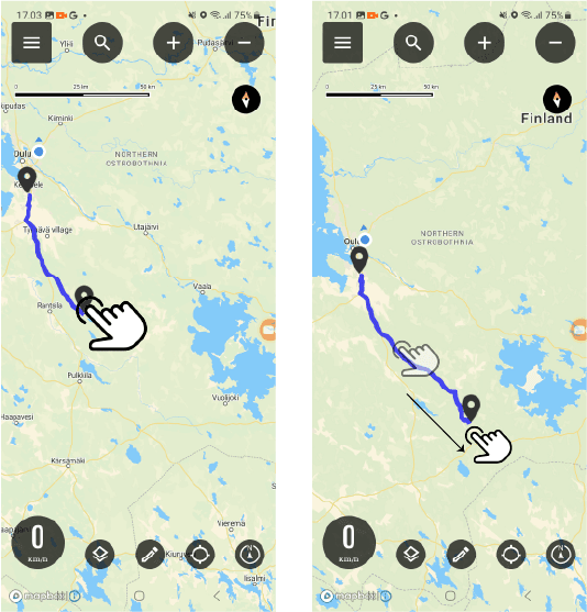
Route planning on the web
Plan your route carefully in advance on your computer and then open it in the mobile app.
Search by map area
You can search for a service station or a specific address on the map area displayed to help you plan.
You can search by typing in the search box:
- Name (Vaasa or Neste Oulunbar)
- Address (Isokatu 10, oulu)
- Category (e.g. petrol stations)


My location
By pressing the location button you can see your location on the map.
In map view
The blue round symbol indicates your location.
Add or remove waypoints right-click. If you are using a tablet, add a period long press.
- You can move the points you added freely on the map
- You can also add waypoints to your route
- To delete points from the map, zoom in on the point first (you cannot delete a point from a distance)
Activities on the map, right mouse button or long press
- Add a waypoint
- Delete waypoint
- Google Street View
The various facilities of the location
Press the location button to change the mode.
My location on the site
You can see your position on the map. And you can pinpoint your location.
In map view
The blue round symbol indicates your location.

My location switched off
By turning off your location, you can easily browse the map.
Map bases
Bikenavi offers 6 different map base options.
Supposition
OpenStreetMap (OSM) is a global map database.
The map contains information about roads, paths, buildings and other points of interest.
Basic (requires subscription)
A base map helps you visualize the overall picture of the area clearly and in detail.
Lightweight (requires subscription)
A light map is simple. It lacks the detailed information of a traditional map. Roads and paths are clearly visible on the map.
Topo (requires subscription)
A topographic map contains a lot of detail, such as elevation contours, small roads, and bodies of water. It is well suited for outdoor activities and visualizing elevation differences.
Outdoor activities (requires reservation)
The Outdoor map is designed for outdoor activities such as hiking and cycling. It provides detailed terrain information and highlights natural elements.
Aerial view (requires subscription)
Aerial photos consisting of satellite images help in visualizing terrain, for example when choosing a campsite.
Coating information (Finland)
Pavement colors on the map. In the application, the information is displayed at zoom level 9.
Asphalt road
Soratie
Cobblestone
Other coating categories
Paved, road surface unknown
Private roads (Finland)
Coloring of private roads on the map. Whether weight and/or vehicle-specific restrictions have been imposed on the road. The information is displayed in the application at zoom level 11.
There are no restrictions on the road.
There are restrictions on the road.
No information about restrictions
Metsähallitus spatial data
Metsähallitus spatial data
You can use Metsähallitus' spatial data in your planning
- Desert hut
- Hut
- Dry toilet
- Cooking canopy/BBQ canopy
- Lean-to, half-hut
- Day care center
- Sauna
- Camping area
- Campfire site
- Rental cabin/rental cabin
Road works (Finland)
You can see the roads in Finland on the map.
Lipas information (Finland)
You will see the following information on the map (location information to be opened later)
- Lavas, kodas, combs
- Screens
- Cooking places
- Mountain biking trails
- Cycling routes
Profile and settings
In settings you can:
- View your current order and
- change default vehicle (motorcycle / moped)
- Open instructions in a new tab
- Open and see what's new in the app
- Log out of the app
Error: The application requires a subscription
If you have placed an order but the app.bikenavi.fi application states 'The application requires a paid subscription', log out and back in. This action will update your order status and fix the problem. If the message does not disappear, please contact our customer support.
The various facilities of the location
Press the location button to change the mode.

Direction of travel (default)
The map always turns in your direction, so you can see where you're going. This is useful when driving off-road.
In map view
The blue round symbol with a cone in front of it indicates the direction of travel.

Direction of travel and tilt
The direction of travel has been selected and the map has been slightly tilted. Navigation is easier.
In map view
The blue round symbol with a cone in front of it indicates the direction of travel.

North locked
Map orientation locked to the north. It is easier to read the map if the direction is north.
In map view
The blue round symbol indicates your location.
The different spaces on the map
Press the symbol to change the mode.
Direction of travel (default)
The map always turns in your direction, so you can see where you're going. This is useful when driving off-road.
In map view
The blue round symbol with a cone in front of it indicates the direction of travel.
North locked
Map orientation locked to the north. It is easier to read the map if the direction is north.
In map view
Blue round symbol indicate one's location
The saved route is immediately visible in the Bikenavi mobile app.
Making a quick route
Quickly make a fast track to your destination by doing the following
(you can enlarge the pictures).
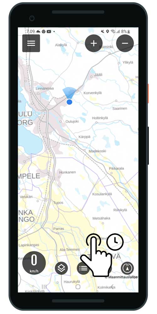
- Choose your destination on the map
- Hox! press long press, until the routing settings open
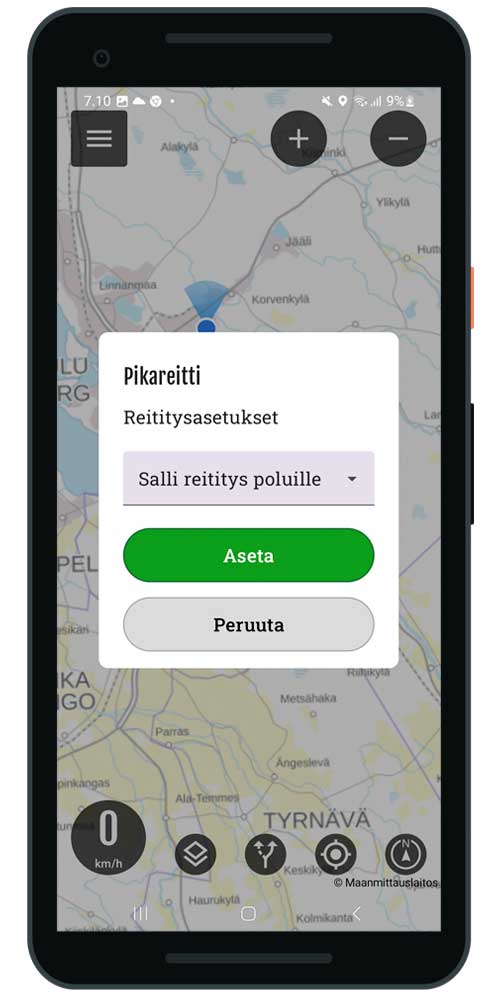
- Select the desired routing setting
- Fastest route
- Allow routing for paths *
- Select set
Only use if you know the route is aDriving on jet skis or motorcycles is allowed.
The route may also include bike paths.
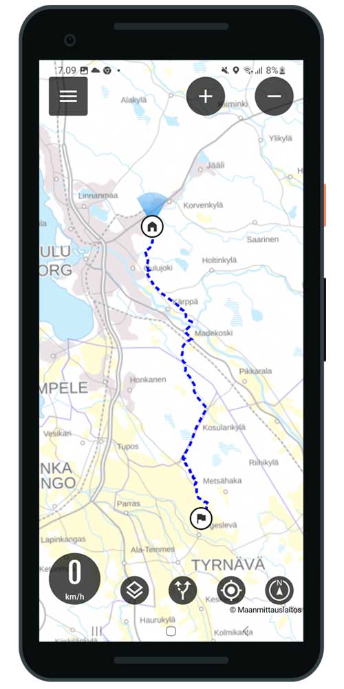
- The route is generated on the map
- Navigate by following the route to your destination
- Routes button to see the length
- Can also hide the route
- You can always make a new route by pressing a button (the old route is overwritten)
Route interruption
- Select routes button in the front view
- Press pause

Map tilt
You can tilt it to make navigation easier.
- Tilt the map with a two-finger gesture
- Pushing forward, tilting the map
- Pulling back, returns the tilt to normal
- Tip: The push and pull gesture with both thumbs works best

Map rotation
- Rotate the map with a two-finger gesture

Dragging the map
- You can move the map by dragging
Have you purchased a Bikanavi subscription? The free version has limited functionality.
You can tilt the map slightly to make navigation easier.

- Tilt the map with a two-finger gesture
- Pushing forward, tilting the map
- Pulling back, returns the tilt to normal
- Tip: The push and pull gesture with both thumbs works best

In the location settings you can also set the tilt of the map.
Connecting CarPlay
The Bikenav iOS app includes support for Apple CarPlay.
- Connect your phone via Bluetooth or cable to an external device or motorcycle system.

Functions and features
- Search
- My routes
- Speed
- The different spaces on the map
- Moving the map
- Zoom function

1 search function
You can search quickly by category.
- Choose a category
- The results are displayed
- You can make a route to the destination of your choice

2 My routes
In My Routes you can see the routes you have planned.
- Choose your preferred route
- The route to the destination is shown on the map
- You can navigate to a destination by following a route

2 Imported routes
In Imported routes, you can see the routes imported into the app.
- Choose your preferred route
- The route to the destination is shown on the map
- You can navigate to a destination by following a route

Other functions (3-6)
3 Speed
- Displays the speed
4 My location
- Locate to your location
5 Moving the map
- You can move the map with the arrow button
- Can be located back to your own location
6 zoom function
- You can zoom the map using the + and - buttons
- Note function cannot be used while the vehicle is moving
You can download the app:
- From AppStore
or
- Google Play
Yes, you can try Route Planning by subscribing to Bikenavi in the app store. The trial lasts for 7 days when you subscribe.
Certain features of the Bikenavi app require a valid subscription, which you can purchase from the Apple Store. You can try the app for free for 7 days with your first subscription.
Once you have placed an order, the app store will send you an order confirmation to your email. You can manage your orders In Apple AccountIf you have any problems with your order, you can contact us. with a feedback form.
Editing
- Select settings
- My routes
- Select the desired route from 3 points edit
- Editing mode opens
In edit mode
- You can change the driving profile
- motorcycle or bicycle
- Routing settings
- Direct route or allow routing for paths
- Avoid motorways
- Avoid unpaved roads
- Avoid ferries
- Avoid customs duties

You can edit your own routes in the mobile app.
To edit waypoints:
- You can move all the points.
- You can continue the route (long press)
- You can delete a point from the route (tap)
Point movement
Select the point you want to move and drag it to the desired location on the map.
Point addition
Add a new waypoint by long pressing on the desired location on the map.

Point removal
Tap the desired waypoint to delete it. The point will be removed from the route.

Order from
Certain features of the Bikenavi app require a valid subscription, which you can purchase Google PlayYou can try the app for free for 7 days with your first subscription.
Once you have placed an order, the app store will send you an order confirmation to your email. You can manage subscriptions on Google PlayIf you have any problems with your order, you can contact us. with a feedback form.
You cannot use app.bikenavi.fi-route planning application for navigation, but With the Bikenavi mobile app navigation is successful.
If you can't find the answer to your question, you can also contact us!